Difference between revisions of "FOS GIS Software Map"
From stgo
m |
|||
| Line 2: | Line 2: | ||
A couple of Projects still need '''to be added''' to the map: | A couple of Projects still need '''to be added''' to the map: | ||
| − | * e.g. | + | * e.g. GeoMoose (Webdev), GeoExt (Webdev) |
* eventually: | * eventually: | ||
** webdev: SLMapViewer, Google Gears, MS DeepZoom/DeepEarth, ModestMaps | ** webdev: SLMapViewer, Google Gears, MS DeepZoom/DeepEarth, ModestMaps | ||
Revision as of 18:15, 3 February 2010
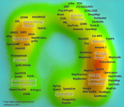
A not complete FOS GIS Software map for an article I am writing on.
A couple of Projects still need to be added to the map:
- e.g. GeoMoose (Webdev), GeoExt (Webdev)
- eventually:
- webdev: SLMapViewer, Google Gears, MS DeepZoom/DeepEarth, ModestMaps
- database/DBMS: MongoDb
- metadata: MDweb (Metadata Registry); GeoNetwork (Metadata Registry), CatMEdit (metadata desktop)
- desktop GIS: GearScape (based on OrbisGIS)
- ETL: Spatial Data Integrator (Talend)
- data/map server: FeatureServer
- libs: Proj4J (projection lib), GDMS (data abstraction layer and SQL), FDO (data access)
Mentioned in the text but will not be in the map, due to development process stage:
- Desktop GIS: Kosmo, OrbisGIS, iGeoDesktop, Whitebox, Puzzle GIS, Kalypso
- DBMS: (1) CouchDB, (2) Ingres Spatial, (3) Hybernate Spatial,
- WPS: Zoo Project
If you have suggestions on projects I missed, please drop me an email sstein[-at=]geo.uzh.ch
Feb 1st, 2010 - stefan
last updated Jan 29th
