Difference between revisions of "FOS GIS Software Map"
From stgo
(Created page with 'a not complete FOS GIS Software map for my article. Couple of Projects still need to be added: e.g. Hugin, GeoMoose, GeoExt, MonoDB?, SLMapViewer?, Google Gears?, MDweb?; DeepZo…') |
m |
||
| (18 intermediate revisions by one user not shown) | |||
| Line 1: | Line 1: | ||
| − | + | * The general overview page: [[Open Source GIS Software]] | |
| + | * The software list itself: [[FOSS4G Software List]] | ||
| − | + | ---- | |
| − | + | Software that needs to be checked / was checked for inclusion: | |
| − | stefan | + | Projects that need '''to be checked''' for the list: |
| + | * eventually: | ||
| + | ** webdev: MS DeepZoom/DeepEarth | ||
| + | ** database/DBMS: --- | ||
| + | ** metadata: --- | ||
| + | ** desktop GIS: | ||
| + | ** ETL: Spatial Data Integrator (Talend) (not open source?) | ||
| + | ** data/map server: --- | ||
| + | ** libs: --- | ||
| + | ** WMS Server: --- | ||
| + | ** WFS Server: --- | ||
| + | ** Image Analysis: [http://www.open-dragon.org/ OpenDragon] (is not open source) | ||
| + | |||
| + | Decided '''not to be in the map''': | ||
| + | * Desktop GIS: Kosmo, iGeoDesktop, Whitebox, Puzzle GIS, Kalypso, GearScape (based on OrbisGIS) | ||
| + | * DBMS: (1) CouchDB, (2) Ingres Spatial, (3) Hybernate Spatial, (4) MongoDB | ||
| + | * WMS server: Mapnik's Paleoserver, QGIS Mapserver, [http://www.constellation-sdi.org Constellation SDI] (seems to be dead) | ||
| + | * WFS server: [http://tinyows.org/trac/wiki/ProjectPresentation TinyOWS] | ||
| + | * Web GIS Developer tools: Google GWT (no continuation of project), SLMapViewer (is for MapServer), MS DeepZoom/DeepEarth, OpenZoom (only for images), ModestMaps (there is not much traffic/activity) | ||
| + | * metadata: MDweb (Metadata Registry); GeoNetwork (Metadata Registry), CatMEdit (metadata desktop) | ||
| + | |||
| + | If you have suggestions on projects I missed, please drop me an email sstein[-at=]geo.uzh.ch | ||
| + | |||
| + | lasy update: Jan 13th, 2012 - stefan | ||
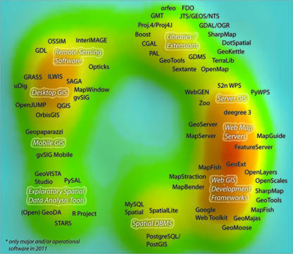
[[File:Projectsmap_v1_150dpi_grey.jpg]] | [[File:Projectsmap_v1_150dpi_grey.jpg]] | ||
Latest revision as of 13:13, 13 January 2012
- The general overview page: Open Source GIS Software
- The software list itself: FOSS4G Software List
Software that needs to be checked / was checked for inclusion:
Projects that need to be checked for the list:
- eventually:
- webdev: MS DeepZoom/DeepEarth
- database/DBMS: ---
- metadata: ---
- desktop GIS:
- ETL: Spatial Data Integrator (Talend) (not open source?)
- data/map server: ---
- libs: ---
- WMS Server: ---
- WFS Server: ---
- Image Analysis: OpenDragon (is not open source)
Decided not to be in the map:
- Desktop GIS: Kosmo, iGeoDesktop, Whitebox, Puzzle GIS, Kalypso, GearScape (based on OrbisGIS)
- DBMS: (1) CouchDB, (2) Ingres Spatial, (3) Hybernate Spatial, (4) MongoDB
- WMS server: Mapnik's Paleoserver, QGIS Mapserver, Constellation SDI (seems to be dead)
- WFS server: TinyOWS
- Web GIS Developer tools: Google GWT (no continuation of project), SLMapViewer (is for MapServer), MS DeepZoom/DeepEarth, OpenZoom (only for images), ModestMaps (there is not much traffic/activity)
- metadata: MDweb (Metadata Registry); GeoNetwork (Metadata Registry), CatMEdit (metadata desktop)
If you have suggestions on projects I missed, please drop me an email sstein[-at=]geo.uzh.ch
lasy update: Jan 13th, 2012 - stefan
